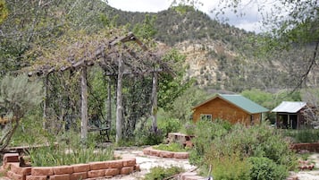
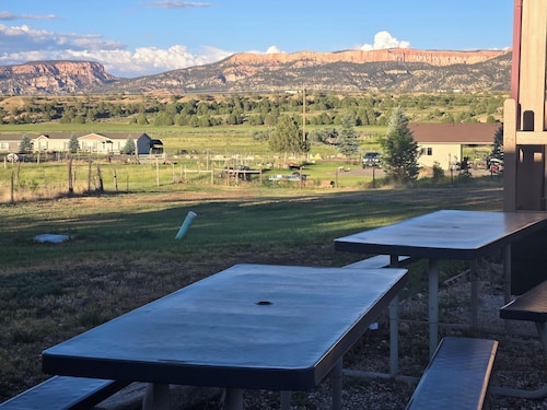
![Take Hwy 89 through the Dixie National Forest. Hot in summer. Beautiful area to explore.
Dixie National Forest is a United States National Forest in Utah with headquarters in Cedar City. It occupies almost two million acres (8,000 km²) and stretches for about 170 miles (270 km) across southern Utah. The largest national forest in Utah, it straddles the divide between the Great Basin and the Colorado River. In descending order of forestland area it is located in parts of Garfield, Washington, Iron, Kane, Wayne, and Piute counties. The majority (over 55%) of forest acreage lies in Garfield County. There are local ranger district offices in Cedar City, Escalante, Panguitch, St. George, and Teasdale.[3]
Elevations vary from 2,800 feet (850 m) above sea level near St. George, Utah to 11,322 feet (3,451 m) at Blue Bell Knoll on Boulder Mountain. The southern rim of the Great Basin, near the Colorado River, provides spectacular scenery. Colorado River canyons are made up of multi-colored cliffs and steep-walled gorges.
The Forest is divided into four geographic areas. High altitude forests in gently rolling hills characterize the Markagunt, Paunsaugunt, and Aquarius Plateaus. Boulder Mountain, one of the largest high-elevation plateaus in the United States, is dotted with hundreds of small lakes 10,000 to 11,000 feet (3,000 to 3,400 m) above sea level. The forest includes the Pine Valley Mountains north of St. George
The Forest has many climatic extremes. Precipitation ranges from 10 inches (250 mm) in the lower elevations to more than 40 inches (1,000 mm) per year near Brian Head Peak 11,307 feet (3,446 m). At the higher elevations, most of the annual precipitation falls as snow. Thunderstorms are common during July and August and produce heavy rains. In some areas, August is the wettest month of the year.
Temperature extremes can be impressive, with summer temperatures exceeding 100 degrees Fahrenheit (38 degrees Celsius) near St. George and winter lows exceeding -30 degrees Fahrenheit (-34 degrees Celsius) on the plateau tops.
The vegetation of the Forest grades from sparse, desert-type plants at the lower elevations to stand of low-growing pinyon pine and juniper dominating the mid-elevations. At the higher elevations, aspen and conifers such as pine, spruce, and fir predominate.
The Dixie Forest Reserve was established on September 25, 1905 by the General Land Office. The name was derived from the local description of the warm southern part of Utah as "Dixie".[4] In 1906 the U.S. Forest Service assumed responsibility for the lands, and on March 4, 1907 it became a National Forest. The western part of Sevier National Forest was added on July 1, 1922, and all of Powell National Forest on October 1, 1944.[5] #RoadTrip](https://images.trvl-media.com/place/553248623139890761/0fda4c56-7838-41e8-8b93-58002efa6942.jpg?impolicy=resizecrop&rw=1920&ra=fit&ch=480)
Foto de Eric & Kristy's Adventures
Hotéis em Alton

Opções de cancelamento grátis caso os planos mudem

Ganhe recompensas em todas as diárias da sua estadia

Economize mais com os Preços para Associados
Consulte os preços para estas datas
Hoje à noite
Amanhã
Este fim de semana
No próximo fim de semana
Onde ficar em Alton?


Historic Smith Hotel B&B
Historic Smith Hotel B&BGlendale
9.2 de 10, Maravilhosa, (501 avaliações)
O preço é de R$ 545
Total: R$ 621
inclui impostos e taxas
28 de mar. – 29 de mar.


Duck Creek Village Inn
Duck Creek Village InnDuck Creek Village
9.4 de 10, Extraordinária, (171 avaliações)
O preço é de R$ 954
Total: R$ 1.120
inclui impostos e taxas
2 de abr. – 3 de abr.

Hatch Station Motel and Restaurant
Hatch Station Motel and RestaurantHatch
8.4 de 10, Muito boa, (413 avaliações)
O preço é de R$ 298
Total: R$ 343
inclui impostos e taxas
16 de abr. – 17 de abr.


The Riverside Ranch RV Park, Motel & Campground
The Riverside Ranch RV Park, Motel & CampgroundHatch
9.4 de 10, Extraordinária, (565 avaliações)
O preço é de R$ 612
Total: R$ 691
inclui impostos e taxas
26 de abr. – 27 de abr.


Arrowhead Country Cabins
Arrowhead Country CabinsMount Carmel
9.6 de 10, Extraordinária, (69 avaliações)


Mountain Ridge Cabins and Lodging
Mountain Ridge Cabins and LodgingHatch
9.2 de 10, Maravilhosa, (990 avaliações)
O preço é de R$ 889
Total: R$ 1.023
inclui impostos e taxas
26 de abr. – 27 de abr.


Galaxy of Hatch between Bryce and Zion
Galaxy of Hatch between Bryce and ZionHatch
8.0 de 10, Muito boa, (24 avaliações)


Best Western East Zion Thunderbird Lodge
Best Western East Zion Thunderbird LodgeOrderville
9.0 de 10, Maravilhosa, (1.002 avaliações)
O preço é de R$ 720
Total: R$ 828
inclui impostos e taxas
15 de abr. – 16 de abr.


The Lodge at Duck Creek
The Lodge at Duck CreekMeadow View Heights
9.4 de 10, Extraordinária, (93 avaliações)
O preço é de R$ 884
Total: R$ 1.795
inclui impostos e taxas
31 de mar. – 1 de abr.


Aspen Cove resort
Aspen Cove resortPanguitch
7.0 de 10, Boa, (66 avaliações)
O preço é de R$ 532
Total: R$ 601
inclui impostos e taxas
28 de mar. – 29 de mar.

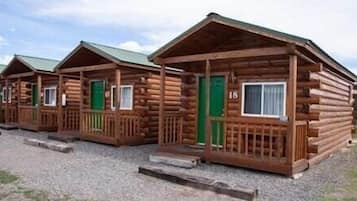
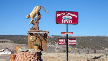
Bryce GatewayInn Cabins
Bryce GatewayInn CabinsPanguitch
8.0 de 10, Muito boa, (785 avaliações)
O preço é de R$ 348
Total: R$ 394
inclui impostos e taxas
28 de mar. – 29 de mar.


Rodeway Inn Bryce Canyon
Rodeway Inn Bryce CanyonPanguitch
8.0 de 10, Muito boa, (1.001 avaliações)
O preço é de R$ 244
Total: R$ 276
inclui impostos e taxas
26 de abr. – 27 de abr.


Quality Inn Panguitch near Bryce Canyon
Quality Inn Panguitch near Bryce CanyonPanguitch
7.8 de 10, Boa, (1.000 avaliações)
O preço é de R$ 372
Total: R$ 420
inclui impostos e taxas
16 de abr. – 17 de abr.


Bryce Canyon Pines
Bryce Canyon PinesBryce Canyon
8.0 de 10, Muito boa, (1.000 avaliações)
O preço é de R$ 372
Total: R$ 420
inclui impostos e taxas
12 de abr. – 13 de abr.


Luxe Home ~ 2 Mi to Bryce Canyon National Park!
Luxe Home ~ 2 Mi to Bryce Canyon National Park!Bryce Canyon
O preço é de R$ 1.600
Total: R$ 2.927
inclui impostos e taxas
23 de abr. – 24 de abr.
Preço mais baixo por diária encontrado nas últimas 24 horas, com base em uma estadia de 1 diária para 2 adultos. Os preços e a disponibilidade estão sujeitos a alterações. Termos adicionais se aplicam.
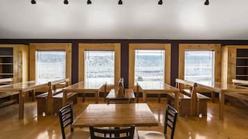
Busque um toque a mais na sua estadia em Alton
Aceita animais
Para famílias
Alton - principais pontos de referência
Mais informações sobre Alton
Alton é um destino conhecido por suas atrações, que incluem Dixie National Forest e Alton Town Hall.
![Take Hwy 89 through the Dixie National Forest. Hot in summer. Beautiful area to explore.
Dixie National Forest is a United States National Forest in Utah with headquarters in Cedar City. It occupies almost two million acres (8,000 km²) and stretches for about 170 miles (270 km) across southern Utah. The largest national forest in Utah, it straddles the divide between the Great Basin and the Colorado River. In descending order of forestland area it is located in parts of Garfield, Washington, Iron, Kane, Wayne, and Piute counties. The majority (over 55%) of forest acreage lies in Garfield County. There are local ranger district offices in Cedar City, Escalante, Panguitch, St. George, and Teasdale.[3]
Elevations vary from 2,800 feet (850 m) above sea level near St. George, Utah to 11,322 feet (3,451 m) at Blue Bell Knoll on Boulder Mountain. The southern rim of the Great Basin, near the Colorado River, provides spectacular scenery. Colorado River canyons are made up of multi-colored cliffs and steep-walled gorges.
The Forest is divided into four geographic areas. High altitude forests in gently rolling hills characterize the Markagunt, Paunsaugunt, and Aquarius Plateaus. Boulder Mountain, one of the largest high-elevation plateaus in the United States, is dotted with hundreds of small lakes 10,000 to 11,000 feet (3,000 to 3,400 m) above sea level. The forest includes the Pine Valley Mountains north of St. George
The Forest has many climatic extremes. Precipitation ranges from 10 inches (250 mm) in the lower elevations to more than 40 inches (1,000 mm) per year near Brian Head Peak 11,307 feet (3,446 m). At the higher elevations, most of the annual precipitation falls as snow. Thunderstorms are common during July and August and produce heavy rains. In some areas, August is the wettest month of the year.
Temperature extremes can be impressive, with summer temperatures exceeding 100 degrees Fahrenheit (38 degrees Celsius) near St. George and winter lows exceeding -30 degrees Fahrenheit (-34 degrees Celsius) on the plateau tops.
The vegetation of the Forest grades from sparse, desert-type plants at the lower elevations to stand of low-growing pinyon pine and juniper dominating the mid-elevations. At the higher elevations, aspen and conifers such as pine, spruce, and fir predominate.
The Dixie Forest Reserve was established on September 25, 1905 by the General Land Office. The name was derived from the local description of the warm southern part of Utah as "Dixie".[4] In 1906 the U.S. Forest Service assumed responsibility for the lands, and on March 4, 1907 it became a National Forest. The western part of Sevier National Forest was added on July 1, 1922, and all of Powell National Forest on October 1, 1944.[5] #RoadTrip](https://images.trvl-media.com/place/553248623139890761/0fda4c56-7838-41e8-8b93-58002efa6942.jpg?impolicy=fcrop&w=900&h=696&p=1&q=high)
Foto de Eric & Kristy's Adventures
Foto grátis de Eric & Kristy's Adventures
Confira avaliações dos hotéis que os hóspedes adoram - Alton
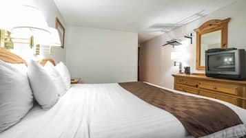
Quality Inn Bryce Canyon
6/10 OK

Perguntas frequentes
Explore outros destinos
- Cabanas - Apple Valley
- Hotéis - Long Valley Junction
- Hotéis 2 estrelas - Hildale
- Hotéis - Bryce Wildlife Adventure e arredores
- Hotéis - Rim Road Scenic Drive e arredores
- Hotéis - Navajo/Queens Garden Loop e arredores
- Hotéis - Old Bryce Town e arredores
- Hotéis - Piracy Point e arredores
- Hotéis - Swamp Canyon e arredores
- Hotéis - Fairview Point e arredores
- Hotéis - Panguitch Lake Resort
- Hotéis - Canyon Point
- Hotéis - Bryce Canyon National Park Visitor Center e arredores
- Hotéis - Glendale
- Hotéis com estacionamento - La Verkin
- Hotéis 3 estrelas - La Verkin
- Hotéis 3 estrelas - Kanab
- Hotéis 3 estrelas - Cannonville
- Hotéis - Cannonville
- Hotéis 3 estrelas - Brian Head
- Hotéis para famílias - Tropic
- Hotéis - Orderville
- Hotéis com academia - Hurricane
- Hotéis baratos - Hurricane
- Hotéis 2 estrelas - Hurricane
- Hotéis 3 estrelas - Hurricane
- Hotéis - Hatch
- Hotéis - Mount Carmel
- Hotéis 2 estrelas - Escalante
- Hotéis com estacionamento - Bryce Canyon
- Hotéis baratos - Bryce Canyon
- Hotéis 2 estrelas - Bryce Canyon
- Hotéis - Bryce Canyon
- Hotéis 2 estrelas - Panguitch
- Hotéis para famílias - Panguitch
- Hotéis - Panguitch
- Hotéis com piscina - Springdale
- Hotéis baratos - Springdale
- Hotéis 2 estrelas - Springdale
- Hotéis 3 estrelas - Springdale
- Hotéis de negócios - Springdale
- Hotéis baratos - Cedar City
- Hotéis 3 estrelas - Cedar City
- Hotéis - Ebenezer's Barn and Grill e arredores
- Hotéis - Red Canyon e arredores
- Hotéis - Caverna de Moqui e arredores
- Hotéis - Inspiration Point e arredores
- Hotéis - Início da trilha Queens Garden e arredores
- Hotéis - Sunrise Point e arredores
- Hotéis 3 estrelas - Duck Creek Village
- Hotéis - Duck Creek Village
- Hotéis - Bryce Point e arredores
- Hotéis - Cascatas Cascade e arredores
- Campings para trailers - The Narrows
- Hotéis baratos - The Narrows e arredores
- Hotéis 2 estrelas - The Narrows
- Hotéis - Red Canyon Visitor Center e arredores
- Hotéis com piscina - Sudoeste de Utah - Bryce Canyon
- Hotéis com academia - Sudoeste de Utah - Bryce Canyon
- Hotéis baratos - Sudoeste de Utah - Bryce Canyon
- Hotéis de luxo - Sudoeste de Utah - Bryce Canyon
- Hotéis de negócios - Sudoeste de Utah - Bryce Canyon
- Hotéis - Condado de Kane
- Hotéis com piscina - Condado de Washington